Land Use
Land use within the county is generally characterized as developed or undeveloped. Developed areas include residential, commercial, and industrial uses; while undeveloped areas are generally agricultural, woodland, and vacant. Understanding land use trends provides the foundation for local and regional decision making that ultimately impact our natural resources. As the chart below shows, approximately 92% of our land is undeveloped. The remaining 8% is developed in high or low density urban areas that are primarily located near the junctions of major transportation routes. These developed areas include: the Shenango Valley (Sharon/Farrell/Hermitage), Greenville, Grove City, and Mercer.
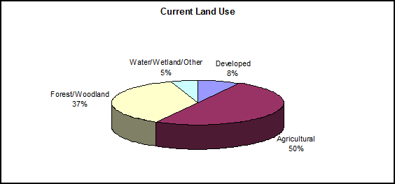
Although the greatest volume of land is agricultural, the greatest threat to the county’s land resources is that of residential development. In spite of the fact that the population had decreased from 1970 through 2000, there was a 46% increase in residential land use from 1973 through 1993. Development and sprawl cause an increase in impervious area and modification of natural drainage patterns. These factors increase runoff and promote stream channel erosion.
LINKS
For more information on land use and planning visit the
Mercer County Regional Planning Commission
http://www.mcrpc.com/
